(version July 14, 2019)
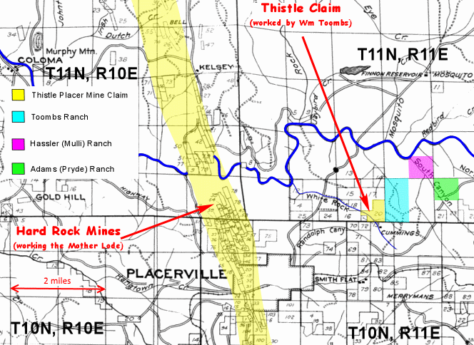
William Toombs bought from Alfred Briggs in 1866 the old Wooster Ranch, which we believe was probably an 80-acre tract in White Rock Canyon in the N/2, NW/4 of Sec 34-T11N-R11E that was once owned by William Wooster (c.1812-1857) and his wife Mary. The Woosters had lived on this ranch, where they operated the Forest Sawmill, but when Mr. Wooster died on May 26, 1857, and was buried in the Old Placerville City Cemetery, he was in debt with a levy placed against the mill and property. Mary likely was forced to sell to settle debts, and Briggs probably bought the ranch from her as an investment. Briggs (1820-1907) was a politician, who from 1854 to 1862 served in the State Legislature for El Dorado County. He was also the local Federal Collector of Internal Revenue when he sold the ranch to William Toombs.
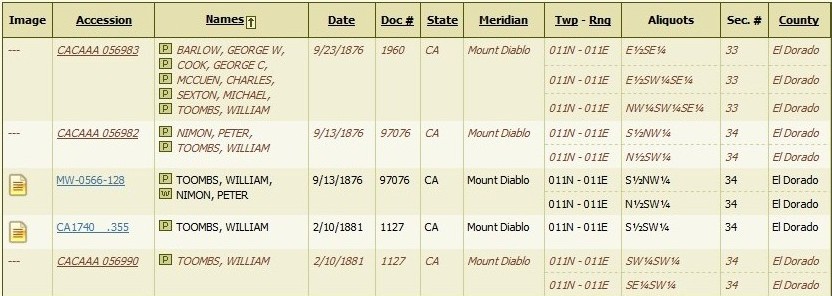
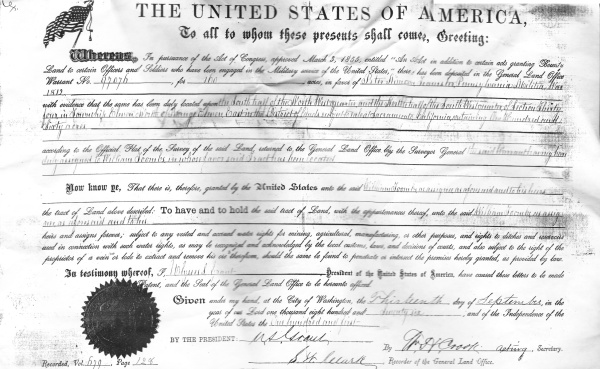
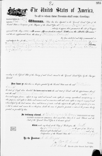
William subsequently added 160 more acres to the ranch, when he was awarded a Federal Patent (full ownership) on Sept. 13, 1876, with Peter Nimon as the grantee, and William as Nimon's assignee (Land Office Doc ID #1127). The patent was awarded under an 1855 Federal act that gave land to individuals who had served in the U.S. Military - Nimon being a veteran of the War of 1812. William then received another patent on Feb. 10, 1881 (Doc ID #97076) that increased the ranch to about 320 acre total, so that it took up most, if not all of the w/2 of Sec. 34, T11N-R11E. The Woosters were forgotten, and the ranch became known as "Toombs White Rock Ranch" or as the old "Toombs Homestead". This is where William and Frances Toombs raised their children, and a large part of the southern area of their ranch today is part of the vineyards for the Lava Cap Winery, which are located near the intersection of Fruitridge and Hassler Roads on the outskirts of Placerville.
When William Toombs died, the Toombs Ranch was divided between his two sons. Charles Gilbert Toombs inherited the south half of the ranch, which contained the family house, and it in time passed to his son Albert William Toombs, who is said to have lost it in a poker game in a Placerville bar. The older son William Louis Toombs inherited the north half, and he eventually sold it to his oldest son Frank Toombs, who planted it in apple trees. Frank had no children, and he offered his apple orchard to his nephew Bob Carty when Bob was looking for a farming venture so that he could move his family out of Hollywood. However, Bob declined the offer, and started a vineyard in Solano County instead. Frank's property was subsequently sold.
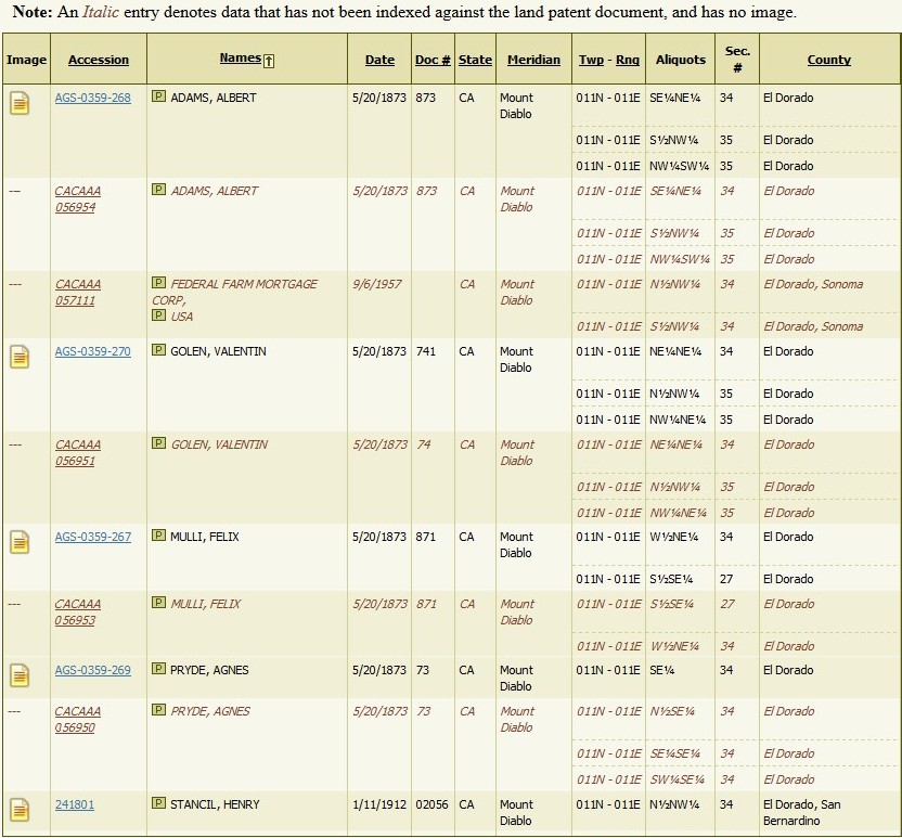
William Toombs, Sr. was also a co-owner of the Thistle Placer Mine, in the SE/4 of Sec 33-T11N-R11E, which was located just to the west of his White Rock Canyon home. He and four partners, one of whom was his son-in-law Michael Sexton, were awarded a patent (full ownership) on Sept. 23, 1876 to the 110-acre claim (Land Office Doc ID #1960). The Toombs family in 1905 still owned the mine when we read that "the Toombs boys property at White Rock has been bonded for $15,000 to C.E. Seymour." Presumably the "Toombs boys refers to William's sonsW illiam Louis Toombs and Charles Gilbert Toombs. The tables shown below are from the website of the Federal Bureau of Land Management, and show the Toombs family land grants, with neighboring Federal land grants.
The United States of America
To all to whom these presents shall come, Greetings:
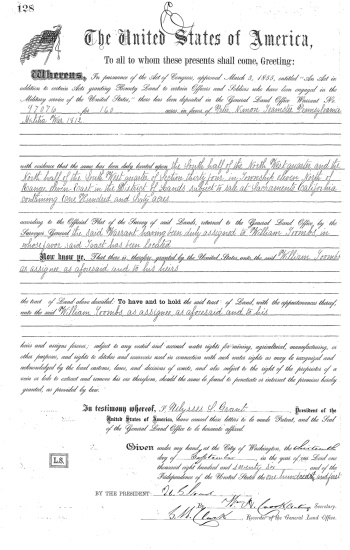
Whereas, In pursuance to the Act of Congress, approved March 3, 1855, entitled, "An Act in addition to certain acts granting Bounty Land to certain Officers and Soldiers who have been engaged in the Military service of the United States," there has been deposited in the General Land Office Warrant No. 97076 , for 160 acres, in favor of Peter Nimon, Teamster, Pennsylvania Militia, War of 1812,
with evidence that the above has been duly located upon the South half of the North West quarter, and the North half of the Southwest quarter of Section Thirty four in Township Eleven North of Range Eleven East in the District of lands subject to sale of Sacramento California containing One Hundred and Sixty Acres
according to the Official Plat of the Survey of the said Land, returned to the General Land Office by the Surveyor General the said Warrant having been duly assigned to William Toombs in whose favor said Tract has been located.
Now know ye, That there is, therefore, granted by the United States unto the said
William Toombs, as assigned as aforesaid and to his heirs the tract of Land above described:
To have and to hold the said tract of Land, with the appurtenances thereof, unto the said
William Toombs, as assignee, as aforesaid and to his
heirs and assigns forever; subject to any vested and accrued water rights for mining, agricultural, manufacturing, or other purposes, and rights to ditches and reservoirs used in conneciton with such water rights, as may be recognized and acknowledged by the local customs, laws, and decisions of courts, and also subject to the right of the proprietor of a vein or lode to extract and remove his ore therefrom, should the same be found to penetrate or intersect the premises hereby granted, as provided by law.
In testimony whereof, P. Ulysses Grant, President of the
United States of America, have caused these letters to be made Patent, and the Seal
of the General Land Office to be hereunto affixed.
Given under my hand, at the City of Washington, the Thirteenth day of September, in the year of our Lord one thousand eight hundred and Seventy six, and of the Independance of the United States the one hundred and first.
BY THE PRESIDENT: U.S. Grant
By Wm. H. Crook acting Secretary, S.W. Clark, Recorder of the General Land Office.
Recorded, Vol. 679, Page 128
The United States of America
To all to whom these presents shall come, Greetings:
Whereas, there has been deposited in the General Land Office of the United States a Certificate of the Register of the Land Office at Sacramento, California , whereby it appears that, pursuant to the Act of Congress, approved 20th of May, 1862, "To secure Homesteads to actual Letters on the Public Domain," and the acts supplemntal thereto, the claim of William Toombs has been established and duly consumated in conformity to law, for the south half of the southwest corner of section thirty-four in township eleven north of range eleven east of Mount Diablo Meridian in California containing 80 acres
according to the Official Plat of the Survey of the said Land, returned to the General Land Office by the Surveyor General.
Now know ye, That there is, therefore, granted by the United States unto the said William Toombs
the tract of Land above described: To have and to hold the said tract of Land, with the appurtenances thereof, unto the said William Toombs and to his heirs and assigns forever; subject to any vested and accrued water rights for mining, agricultural, manufacturing, or other purposes, and rights to ditches and reservoirs used in conneciton with such water rights, as may be recognized and acknowledged by the local customs, laws, and decisions of courts, and also subject to the right of the proprietor of a vein or lode to extract and remove his ore therefrom, should the same be found to penetrate or intersect the premises hereby granted, as provided by law.
In testimony whereof, P. Rutherford B. Hays , President of the
United States of America, have caused these letters to be made Patent, and the Seal
of the General Land Office to be hereunto affixed.
Given under my hand, at the City of Washington, the tenth day of February, in the year of our Lord one thousand eight hundred and eighty-one, and of the Independance of the United States the one hundred and fifth.
BY THE PRESIDENT: R.B. Hays
By Wm. H. Crook Secretary, S.W. Clark, Recorder of the General Land Office.
